

Kayak Navigation
Come and get the right equipment the first time. We can assist you with training and suitable equipment for your day to day paddling and preparation for expeditions.
Field Compass
Deck Compass
GPS Navigation Systems
East Coast Kayaking can provide training in navigation - basic principles on navigation for kayakers and also electronic navigation techniques (GPS use and marine chart trip planning) - contact us for Private Tuition sessions tailored to your needs or course dates.
Field Compass
The Silva Field Compass is a basic handheld compass that is useful for both on-water and off-water planning. As well as the compass-orientation function it has a millimeter scale and scales for 1:25,000 and 1:50,000 maps.
This is a handy small compass to keep in your PFD pocket or on-deck map pocket.

Silva Field Compass
Deck Mounted Compasses
For expedition paddling or keeping on course when doing long crossings it is useful to have a deck-mounted compass to help keep you on course. Ideally, when paddling in sight of land, you should align yourself with landmarks, rather than continually looking down at the compass (this may lead to sea-sickness!).
Two types of deck compasses exist - those fixed to the deck through a permanently mounted bezel (the compass is removable and clicks into the bezel), such as the Richie Kayak Compass and the Silva 70P Compass or one temporarily fixed to the deck using shock cord and nylon hooks (included) - the Silva 58 Kayak Compass.
A detachable compass has the benefit that you can swap it between kayaks or store it when not needed. A compass fixed to the deck is set & forget, plus the numbers are bigger and easier to read! Different compasses fit different kayaks - the Ritchie compass fits the recessed area on Mirage and Nadgee Sea Kayaks, while the Silva 70P fits the angled square recess on Valley and Seabird Sea Kayaks.

Ritchie Compass

Silva 70P Compass

Silva 58 Kayak Compass
GPS Navigation System
A GPS unit is a great tool for monitoring your speed, course and for finding hard to spot camping sites on an expedition. We use and recommend the Garmin GPSMAP 78sc which comes pre-loaded with Australian & NZ marine charts. Garmin make a number of excellent GPS models - we prefer this one as it has press-button operation rather than touchscreen (which can be harder to operate with wet hands). The screen is still a good size - we tend to operate it on either the Compass or a trip computer screen rather than leaving it on Map as this saves the battery power.
More information on GPS operation and using HomePort software to plan your trip can be found in our Blog.
A note on waterproof ratings: The Garmin GPSMAP 78sc is rated at IPX7 meaning it withstands incidental exposure to water of up to 1 meter for up to 30 minutes, ie. indoor/outdoor use in the presence of rain, snow or brief splashes of water. Not suitable for any immersion of more than 1 meter, regardless of duration of immersion, or any immersion of more than 30 minutes, regardless of depth of immersion.
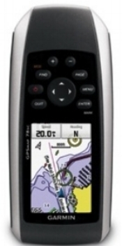
Garmin GPSMap 78sc
We therefore recommend that you use your GPS unit in a waterproof bag - it will fit inside an Aquapac 358.
Alternatives to a dedicated GPS unit are to carry an iPad Mini in a waterproof case (or even use your phone but do be careful you are not flattening the battery on your primary communications tool!) with Navionics software installed. These are marine charts and a GPS enabled device will show your position even where there is no cell-phone signal.
Make sure you are fully familiar with the charts for the area of your expedition prior to leaving (including effects of tides and prevailing winds for the area) - a GPS does not replace a good knowledge of how to navigate. It is best to have a printout (laminated or on tough/waterproof paper) on your deck as insurance against flat batteries.